The Lemosho Route
Tanzania's most scenic and most successful Kilimanjaro route – a seven-day approach from the remote western forests, across the wild Shira Plateau, over the Barranco Wall, and on to Uhuru Peak.
The Kilimanjaro Lemosho Route begins on the remote western side of the mountain, near the Lemosho Glades, and is widely considered the most beautiful and rewarding way to approach Kibo. Like Machame, it is a traverse – you ascend through different terrain than you descend – but Lemosho starts further from the peak, giving you an extra day of gradual altitude gain through pristine, rarely-visited rainforest before you ever reach the busier trails on the south side.
The route crosses the Shira Ridge onto the vast Shira Plateau, continues past the volcanic Lava Tower (the "Shark's Tooth") at 4,600 metres, and descends into the dramatic Barranco Valley before joining the same final approach used by Machame climbers. This longer, more gradual profile – with more time spent at moderate altitude before the big pushes – is the main reason Lemosho consistently records some of the highest summit success rates of any route on the mountain.
All camping equipment, meals, crew wages, and park fees are included. Our guides carry emergency oxygen, a pulse oximeter, and wilderness first-aid certification. Group size is capped at six climbers per guide to ensure personal attention throughout the climb.
The drive from Moshi or Arusha to Londorossi Gate on the western side of the mountain takes around 2.5–3 hours, passing through highland farmland and pine plantations before reaching the park boundary. After registration, a further drive brings you to the Lemosho trailhead, from where the trek begins in dense, untouched montane rainforest – among the wildest and least-visited forest on Kilimanjaro. Look out for blue monkeys, colobus, and fresh elephant or buffalo tracks along the trail. Camp is set in a clearing among towering podocarpus trees, hence the name "Big Tree Camp".
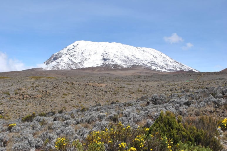
A long but spectacular day. Leaving the forest behind, the trail climbs steadily through heather and giant groundsel onto the Shira Ridge – one of the finest viewpoints on the mountain, with Mount Meru often visible to the west across the clouds. Beyond the ridge, the path drops gently onto the vast Shira Plateau, the floor of an ancient collapsed volcanic caldera, now a high-altitude desert of tussock grass and everlasting flowers. Camp is pitched on the eastern edge of the plateau with sweeping views toward Kibo's western flank.
For those opting for the extended 8-day variation, the long climb onto the plateau is split into two gentler days, with an overnight stop at Shira 1 Camp before continuing across to Shira 2 the following morning. This extra night at moderate altitude further improves acclimatisation and is recommended for first-time high-altitude trekkers or anyone with extra time to spare.
The most important acclimatisation day on the route. From Shira 2 the trail climbs steadily across rocky alpine desert toward the base of Kibo, reaching the Lava Tower – a dramatic volcanic plug nicknamed the "Shark's Tooth" – at 4,600m, where most groups stop for lunch. Although Barranco Camp sits at roughly the same altitude as the morning's start, the high point reached at the Lava Tower triggers the "climb high, sleep low" acclimatisation response that is critical for summit night. The descent into the Barranco Valley reveals giant lobelias and senecios – plants found almost nowhere else on Earth – with the Barranco Wall looming directly ahead.
The day begins with the famous Barranco Wall – a steep but non-technical scramble that gains around 300m in under an hour, with some of the best views on the entire mountain from the top. Beyond the wall, the trail undulates across a series of ridges and valleys, with Kibo's southern glaciers visible above whenever the clouds clear. Karanga Camp, reached by early afternoon, is the last reliable water source before the summit – porters top up water supplies here for the climb ahead.
A deliberately short day, designed to let the body rest before summit night. The trail climbs steadily over rocky ground, joining the route used by climbers coming up from Mweka, to reach Barafu – the exposed "high camp" perched on a ridge below the Southern Icefields. The twin summits of Mawenzi and Kibo dominate the view from camp. The afternoon is spent resting, hydrating, and running through final kit checks with your guide before an early dinner and lights-out well before the midnight departure.
Departure begins around midnight, ascending northwest through heavy scree in the dark toward the crater rim. This is the most physically and mentally demanding section of the entire trek. At Stella Point (5,685m) you stop briefly – and if conditions allow, you will see one of the most magnificent sunrises of your life break over Mawenzi. From Stella Point it is one further hour across the crater's snowy rim to Uhuru Peak at 5,895m: the highest point in Africa. After summit photographs, you descend directly to Mweka Camp, stopping at Barafu for a late breakfast. Gaiters and trekking poles are essential for the loose scree descent.
After breakfast, you make the final descent through upper rainforest to the Mweka Park Gate, where summit certificates are presented to all those who reached Stella Point or above. At lower elevations the trail can be wet and muddy – gaiters help. A vehicle meets you at Mweka Village and transfers you back to your hotel in Moshi or Arusha. Don't forget to tip your guides and porters. Tonight: a well-earned celebration dinner.
Getting to Kilimanjaro
This tour starts on the western side of the mountain and ends on the southern side, in the Kilimanjaro region. Our team handles all ground logistics from the moment you arrive at the airport.